Did you know that the Earth's magnetic poles do not exactly coincide with the geographic poles? Because of this, the magnetic declination at a specific point is calculated. an essential concept for both maritime and air navigation. In this article we will explain everything you need to know about what magnetic declination is and how to calculate it. You just have to keep reading.
What is magnetic declination?
As we have already mentioned, the Earth's North Pole and the magnetic North Pole do not coincide. Magnetic declination is the angle between the geographic north and the magnetic north. It is the angle between the geographic north and the angle indicated by a compass, which represents the magnetic declination.. But to understand it well, you must be clear about the following concepts:
- Terrestrial Magnetism: The Earth creates its own magnetic field due to the electrical currents that occur in its liquid nickel and iron core. Hence, it acts like a magnet with two magnetic poles: north pole and south pole. The magnetic north pole is located in the South, close to the geographic South Pole, while the magnetic south pole is located in the North, close to the geographic North Pole.
- Geographic North: It is known as true north. It coincides with the axis of rotation of the Earth and defines its intersection with the planet's surface at two points; the geographic north at the North Pole and the geographic south at the South Pole.
- magnetic north: This is the point where nautical compasses point. It is defined by the Earth's magnetic field, which includes the magnetic variation at different points on the Earth. Its position does not coincide with the geographic north and moves from year to year. To give us an idea, throughout the 20th century its position varied by 1,100 kilometres. On average, the magnetic north changes its position by about 60 kilometres per year.
Once these three concepts have been explained, we can say that the angle between magnetic North and true North is called magnetic declination. Since the Earth's magnetism is not the same at all points, Magnetic declination is not a fixed value but varies depending on the point where we are and with the passage of time.I was. Since the Earth's magnetism is not the same at all points, Magnetic declination is not a fixed value but varies depending on the point where we are and with the passage of time.
Why is magnetic declination important?
As we have already mentioned, magnetic declination is not stable. Depending on where we are, its value can vary. Furthermore, due to the rotation and translation of the Earth and the effect of magnetic variation, this value of magnetic declination also changes over time.
Therefore, knowing the magnetic declination helps us to have an idea about the margins of error and calculation errors that exist in measurement systems.
Are you interested in: Nautical needle
How to calculate magnetic declination?
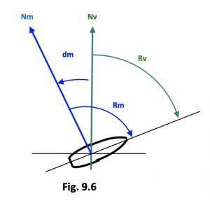
The magnetic declination, in cases where it is unknown, can be calculated through the nautical chart. To know the value of the magnetic declination we must know that, if magnetic north is located to the right of true north, the magnetic declination is positive.
On the other hand, if magnetic north is located to the left of true north, the magnetic declination will have a negative value.
In this way, it can be said that the true heading is equal to the algebraic sum of the value of the true heading is equal to:
Rv = Rm + (- dm) ;
Rm = Rv + dm
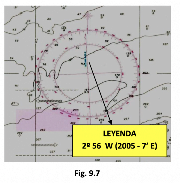
When we analyze nautical charts we can find values of a graduated circle between 0 and 360 degrees that indicates the value of the magnetic declination for the year of publication of said chart. In addition, it usually tells us the value of the annual variation of this magnetic declination depending on the movement of the magnetic north pole.
How to correct the magnetic declination?
To update the magnetic declination calculation, you must take note of the legend that appears on the chart. For example, if the nautical chart shows 2º 56' W 2005 (7'E), its meaning is as follows: the declination is 2º 56' W, i.e. negative for 2005 and its annual variation is 7' E, i.e. positive. This means that for each year that passes after 2006 on the chart, we will have to subtract 7', so, for example, in 2020 it was 2º 56' – 0º 7' = 2º 49'. However, it is advisable to follow these steps:
1. Calculate the difference in years that exists between the date you want to calculate and the date on the letter. Suppose we want to know the magnetic declination for the year 2010. In this case it will be 5 years (2010-2005)
2. Multiply the years of difference by the annual variation, in this case it is 7', therefore it would be 5×7=35'
3. Add or subtract, in the case of the figure it is subtract since the dm is at W and therefore negative and the annual variation is positive, the variation suffered during the 5 years to that which existed in 2005, thus: 2º 56' – 0º 35' = 2º 21' W.
In the case of having to update the magnetic declination for a year prior to the one that appears on the chart, the same procedure is followed, but in the third point the result would be added to the magnetic declination by one point.
To carry out work on letters, the dm will be approximated to half a degree, taking into account that we are in the sexagesimal system, thus in the previous example, 2º 21' is equivalent to 2.35º and is approximated in decimal to 2.5º.
If you want to continue learning about navigation, you can consult some of our pleasure boat skipper courses. At Anclademia we train you so that you can pass the PER exam. Consult all the information about our course.